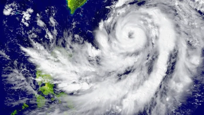

Super Typhoon Bavi, one of the most powerful tropical cyclones to directly strike land in the western Pacific in recorded history, made landfall on the tiny US island of Rota in the Northern Mariana Islands early Monday morning local time, battering the island and surrounding US territories with sustained winds of 180 mph and gusts exceeding 200 mph. The storm produced catastrophic damage across Rota and severe impacts on Guam, Saipan and Tinian before beginning to track away from the Marianas — and is now forecast to reach northern Taiwan and Japan’s Ryukyu Islands by Friday as a still-dangerous and significantly larger storm.
The Strike on Rota
Super Typhoon Bavi blasted through the US Northern Mariana Islands just after sunrise Monday local time as a high-end Category 5 storm with 180 mph winds. The eye of the storm completely encompassed the small island of Rota, which likely suffered severe to catastrophic damage.
At 08:40 local time on July 6, Bavi passed extremely close to the northern coast of the island of Rota as a Category 5 super typhoon, becoming one of the strongest typhoons in history to affect the Northern Mariana Islands.
The National Weather Service recorded winds exceeding 150 mph. Officials around the territory reported flash floods, flipped cars, and extensive damage. A communications tower fell, causing cell phone services to go down. An island-wide power outage was reported in Saipan. Flash flood warnings were put into effect for Saipan and Tinian.
Local authorities on Rota said they had received reports of “major damages.” The Rota Municipal Operations Centre’s public information officer, Lou Rosario, said: “We are hanging in there. We are experiencing heavy winds and flooding here… Some people are already reporting major damages.”
Gusts of 106 mph were also recorded at Saipan International Airport and 100 mph at Guam International Airport. Guam International Airport recorded a rainfall total of 12.31 inches — a daily record. The islands remain under the threat of major flooding from additional rain on top of 12 to 18 inches that had already fallen in parts of Guam.
A Territory Already Pushed to the Limit
The Marianas are not recovering from Bavi with a clean slate. The typhoon made landfall on Monday morning local time, with the eye of the storm passing directly over the island of Rota. But the territory was already severely burdened before the storm arrived.
“The typhoons this year are bringing us almost to a crippled state in the region,” said Landon Aydlett, National Weather Service warning coordination meteorologist. He noted that upwards of 1,300 families are still living in tents because the first super typhoon — Sinlaku — hit the Northern Mariana Islands in April. “Right after another super typhoon came that parked itself, it was moving three or four mph over those northern two islands, causing significant damage over a three-day period. People still have no power up there.”
The arrival of Bavi just three months after Sinlaku has left the islands’ infrastructure and residents with no meaningful recovery period between major cyclone events. Less than three months ago, Category 4 Super Typhoon Sinlaku clobbered the Northern Marianas and Guam with damaging winds, storm surge and rainfall flooding, causing an estimated $1.5 billion or more in damage.
The cumulative damage — two Category 4 or 5 systems in three months — is pushing a US territory with approximately 210,000 residents toward a genuine humanitarian crisis, with power systems, communications infrastructure, housing and public services all degraded by compounding storms.
What Made Bavi So Powerful
Bavi hit Rota at peak intensity: 180 mph winds with a central pressure of 910 mb. This is quite close to the maximum potential intensity that a tropical cyclone can have under the prevailing atmospheric and oceanic conditions — about 200 mph with a central pressure of 885 mb. It is quite rare for a hurricane or typhoon to reach its maximum potential intensity — all conditions have to be perfect.
Bavi became a super typhoon less than a day after being named, following explosive intensification over very warm sea surface temperatures and low vertical wind shear. The western Pacific’s sea surface temperatures in 2026 have been elevated by the same climate dynamics driving extreme heat events across Europe, the United States and Asia — providing the thermodynamic fuel for rapid intensification to rare intensities.
This El Niño season is expected to continue with a lot more tropical cyclone activity in the Pacific. The 2026 Pacific typhoon season has already produced two super typhoons affecting the Marianas — Sinlaku in April and now Bavi — a pace that is exceptional and that climate scientists connect to the broader pattern of warming ocean temperatures increasing the frequency and intensity of high-end cyclones.
Where Bavi Is Going — Taiwan in the Crosshairs
Having passed through the Marianas, Bavi has turned its attention toward Asia. The Joint Typhoon Warning Center predicts that wind shear will increase to a high level by Tuesday, resulting in considerable weakening beginning Wednesday, with the typhoon dropping to Category 3 strength by Friday, July 10, when it will be threatening northern Taiwan and Japan’s Ryukyu Islands. Bavi will track clockwise around a strong ridge of high pressure, bending toward a more northwesterly track by Wednesday. This track should carry the storm near or over northern Taiwan and/or Japan’s Ryukyu Islands on Friday and into China south of Shanghai on Saturday.
Though the typhoon’s winds will be weaker when it hits Asia, Bavi will be expanding greatly in size, bringing widespread storm-surge flooding, rainfall, and damaging winds. Flash flooding and power outages will be likely for the Taipei metro area.
Taiwan’s Central Weather Administration is already tracking Bavi’s approach and has begun preparedness briefings for coastal regions. A storm of Category 3 intensity making landfall on or near Taiwan would be a significant disaster for the island, which is home to 23 million people and hosts semiconductor manufacturing facilities whose disruption would have immediate global economic consequences.
The FEMA Response
FEMA stated that it will support Guam and the Northern Mariana Islands as soon as the typhoon moves through. All flights had been cancelled at the main airports across the region. Operations were suspended at several ports. The speed of the damage assessment — and whether power and communications can be restored before the rainy season’s next system arrives — will determine whether the Marianas can stabilise before facing further cyclone threats.